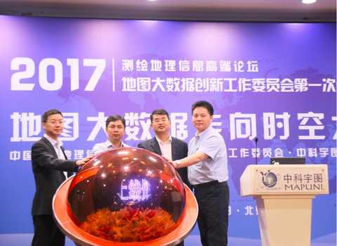
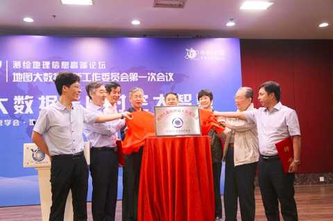
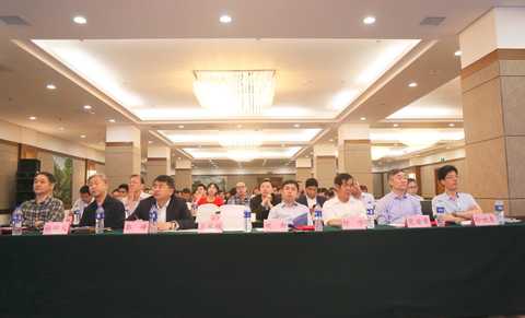
In the era of big data, the geographic information industry is an important branch of the information industry. Due to the wide application of spatial data, large data volume and large data value, it is an indispensable important part of the big data industry. Maps are the most important form of geographic information, and the amount of information carried by map data is increasing. Especially in the use of big data thinking and analysis methods to interpret map data, the value of data behind map information is more displayed. And analyze it out. Today, map big data has a wide range of applications in public services, people's livelihood projects, aerospace, government services and many other fields. Zhongke Yutu and Huawei Enterprise Cloud built a map cloud and an environmental protection cloud. On May 12th, hosted by China Society of Surveying and Mapping Geographic Information, the 2017 Surveying and Mapping Geographic Information High-end Forum hosted by Zhongke Yutu Technology Co., Ltd. was successfully held in Beijing. Experts, scholars, companies and users from the field of geographic information gathered together to discuss the future development of map big data with the theme of “Map Big Data Going to Time and Space Wisdomâ€. During the meeting, the conference held the inauguration ceremony of the Map Big Data Innovation Working Committee and the ceremony of the construction of the map cloud and the environmental protection cloud on the cloud of Zhongke Yutu and Huawei Enterprise Cloud. The establishment of the committee will play a leading role in the construction of smart cities. Inauguration Ceremony of Map Big Data Innovation Working Committee Experts, scholars, companies and users from the field of geographic information gathered together Time and space big data platform is the brain of new smart city A smart city must have a brain. This brain is a space-time big data platform. Time and space big data are increasingly becoming the core driving force for the modernization of governance system and governance capacity, including the current diversification of governance objects, and the main body of participation in social governance from the single government to the government, non-governmental organizations, public individuals, etc. Excessive system, the effect of governance must be precise, which is urgently required to improve the level of intelligence of the city's own governance. At the meeting, Wang Jiayao, an academician of the Chinese Academy of Engineering, focused on the status quo of smart city construction, the problems in the construction of smart cities, the connotation of new smart cities, the development of time and space big data industries, and the like, with the theme of "Time and Space Big Data Platform - The Brain of New Smart City". In terms of how the current smart city solves the challenges of “big city disease†and the development of time and space big data industry, it puts forward its own views. Wang Jiayao said that for the current "urban disease" phenomenon in cities, the Map Big Data Innovation Working Committee must play a leading role in the construction of smart cities. When talking about the development of time-space big data industrialization, Wang Jiayao said, "The emergence of time-space big data industrialization has not yet started, the big data technology system has not been built, and the data value brought by the unclear boundaries of time and space big data cannot be unearthed. Is a problem that must be solved urgently on the road to industrialization." The author believes that map big data + will be a key to the future of the letter industry in the construction of smart cities, how to use this key depends on whether time and space big data can change the understanding of the data, not only the technical level, but more important How to change the mindset. Data boundaries are defined and data is standardized to achieve data sharing, thereby realizing the value of map big data. Refined urban management is the core of smart city construction The fourth Central City Work Conference, held in December 2015, emphasized the need to promote the steady development of new smart cities. In particular, in terms of urban management, on the one hand, efforts are made at both ends of construction and management to transform the urban development mode, improve the urban governance system, and improve urban governance capabilities. In terms of refined urban management, it is mentioned that it is necessary to strengthen the integration of urban management and platform construction and functions, build a comprehensive urban management database, and develop smart applications for people's livelihood services. In the area of ​​refined urban management, Professor Du Mingyi, Dean of the School of Surveying and Urban Space Information of Beijing Jianzhu University, put forward some new ideas. Traditionally, sensor positioning methods are often based on traditional methods of measuring front intersection. However, if you want to monitor a city and arrange base stations in a large area of ​​the city, the cost will be high. If we follow the current Internet of Things or sensor-based RFID, the city will be overwhelmed and at least economically overwhelmed. In response to this situation, the vehicle-sensing positioning technology developed by the vehicle can locate the position of the vehicle, place the base station of the sensor or the base station of the Internet of Things on the vehicle, and locate a multi-tag by one base station, buy several cars, and put on the base station. , greatly reducing the cost of the city's Internet of Things. Fine management, especially attention to detail, based on professionalism, from a more detailed point of view, to simplify complex things, simple things process, process things to quantify, on a quantitative basis to achieve refinement . In the deep farming industry map, Keyu map leads innovation development On the issue of data application in smart cities, Sun Shiyou, director of the China University of Surveying and Mapping Geographic Information Society's Map Big Data Innovation Working Committee and vice president of Zhongke Yutu Technology Co., Ltd., said in an interview with the Taber network reporter that Zhongke Yutu made a map. The data is serving a wide range of industries. In the construction of smart cities, especially in the fields of smart environmental protection and smart water conservancy, Zhongke Yutu has successful application cases throughout the country. Sun Shiyou believes that in the field of smart city segmentation, such as smart medical care, smart and environmental protection, each field must establish a standard model. Map big data including other data parameters can be applied to the model to truly realize the smart city. In fact, the construction of a smart city should integrate the effective data generated by each intelligence into a platform for analysis, rather than a single field to realize that smart is a smart city, it emphasizes the integration of the entire field. “Map big data is a foundation of our social application and plays a supporting role in the industry. Maps big data can be used in various industries, which meets the needs and applications of the market and enhances the management functions of map big data. In the practical application of map big data must rely on technology as a supplement, business-led thinking, can really solve the actual problem." Sun Shiyou added. For the application of large map data, Zhongke Yutu Company, which has been established for more than ten years, has rich experience. Its business has started from remote sensing and maps, and now it has formed two major ecological circles of “map big data†and “great capital ringâ€. It has created a national industry map basic database, which is actively expanding from the aspects of data accuracy, richness and applicability. The production and application of large map data should establish a unified standard to promote its large-scale application in various fields. universal. Taking Zhongke Yutu as an example, the company emphasizes the comprehensive drawing ability in technology, forms a complete standard of drawing technology, builds a set of map production process standards and processes, and establishes a scaled data generation method, from work efficiency and The quality of the products can be better guaranteed. At the meeting, Tong Yuan, vice president of Zhongke Yutu Technology Co., Ltd., expressed his views when talking about the topic of smart city. Whether it is doing maps or doing environmental protection and water conservancy, Zhongke Yutu hopes to be in a smart city. Beautiful villages include beautiful China to contribute. Based on the map big data and space-time information cloud platform, Zhongke Yutu provides comprehensive solutions for environmental protection, water management, disaster prevention and mitigation, and vigorously promotes the construction of smart cities. The management and operation of a city requires scientific decision-making, and only data support can guarantee the true operation of a smart city. Urban development needs to complete the collection, processing, integration, sharing, mining, analysis and application of big data. By understanding the operation and development of the city, it provides support for the joint work and leadership decision-making of various departments. Only in this way can we transform the original technology-oriented, rather than the civic experience-oriented construction ideas, so that the construction of smart cities truly benefits the public. Editor in charge: Xing Xingchen Gift Box Socks,Winter Kids Socks,Womens Tube Socks,Kids Cotton Socks Shaoxing Evergreen Knitting Co., Ltd. , https://www.egsock.com